Privacy Overview
This website uses cookies to improve your experience while you navigate through the website. Out of these, the cookies that are categorized as necessary are stored on your browser as they are essential for the working of basic functionalities of the website. We also use third-party cookies that help us analyze and understand how you use this website. These cookies will be stored in your browser only with your consent. You also have the option to opt-out of these cookies. But opting out of some of these cookies may affect your browsing experience.
Always Active
Necessary cookies are absolutely essential for the website to function properly. These cookies ensure basic functionalities and security features of the website, anonymously.
Functional cookies help to perform certain functionalities like sharing the content of the website on social media platforms, collect feedbacks, and other third-party features.

No cookies to display.

Performance cookies are used to understand and analyze the key performance indexes of the website which helps in delivering a better user experience for the visitors.

No cookies to display.

Analytical cookies are used to understand how visitors interact with the website. These cookies help provide information on metrics the number of visitors, bounce rate, traffic source, etc.

No cookies to display.

Advertisement cookies are used to provide visitors with relevant ads and marketing campaigns. These cookies track visitors across websites and collect information to provide customized ads.

No cookies to display.

Other uncategorized cookies are those that are being analyzed and have not been classified into a category as yet.

No cookies to display.

Welcome

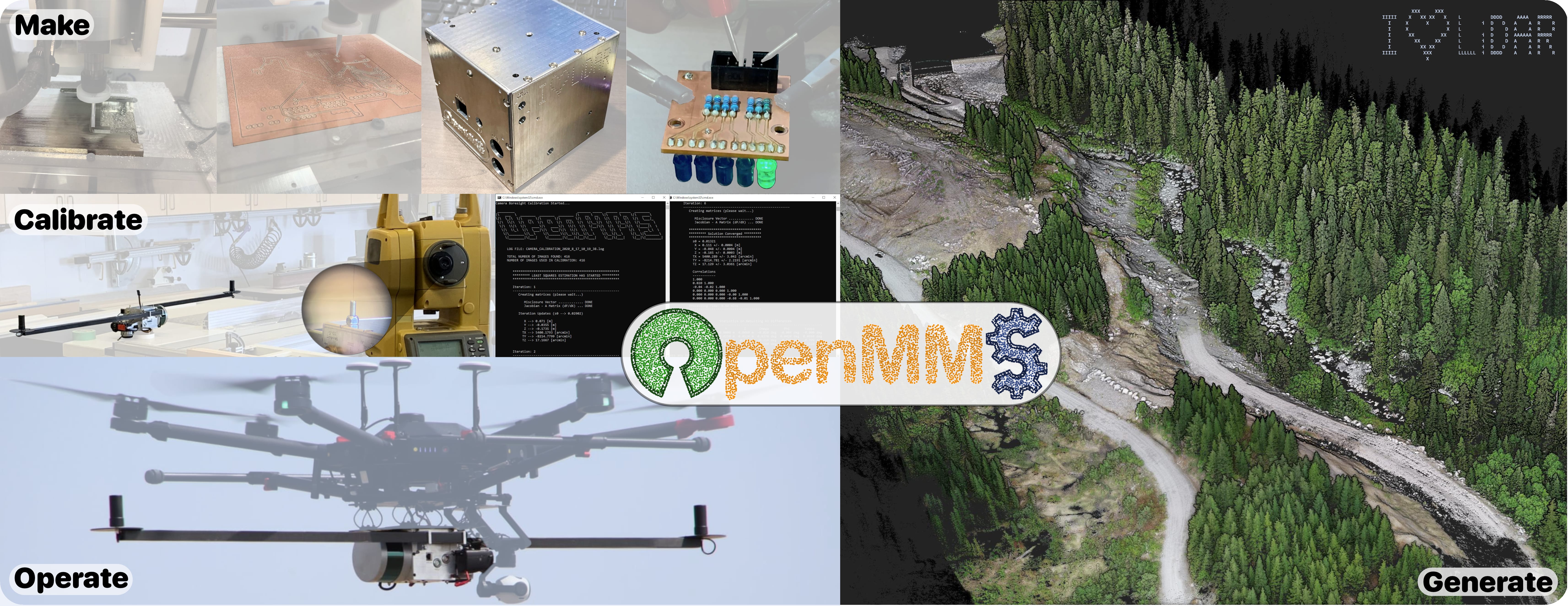
What is OpenMMS all about? Check out the project video to find out!

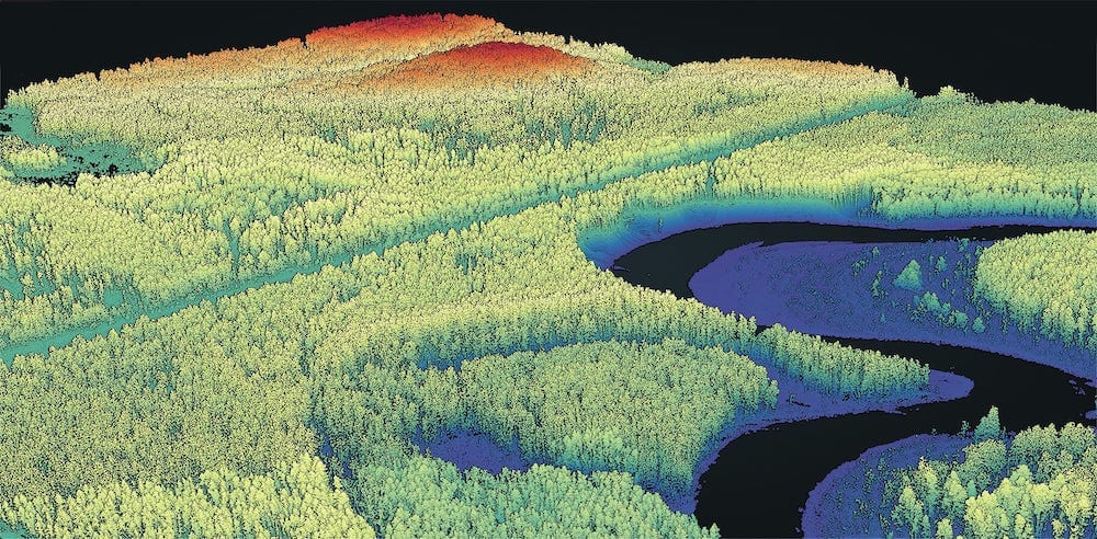
Small, lightweight mobile mapping systems (MMS), especially those installed on remotely piloted aircraft systems (RPAS/UAS), have gained a lot of interest in academic research and commercial industries. The Open Mobile Mapping System project, code-named OMMS (Ω) project, is an innovative open-source software and hardware research initiative. The project aims to provide an interested user with the necessary theoretical knowledge, technical knowledge, and hands-on skills to make, calibrate, and operate their own professional mobile mapping system. This project presents a single source of information that lists every nut, bolt, OEM sensor, and manufacturing step required to build a modern, tightly-integrated MMS sensor. The project also includes a robust suite of novel open-source software applications that rigorously process the collected data and generate industry-standard geospatial deliverables.* The system’s firmware, calibration procedures, and quality control workflows also utilize newly developed open-source software.

The complete OpenMMS solution provides many of the same features and achieves the same (or better) accuracy specifications as comparable commercial systems. The hardware combines a lidar sensor, global navigation satellite system sensors, an inertial sensor, cameras, and computers, to create a tightly-integrated digital mapping tool. The software is easy to use, fast, supports multiple OS, and, when possible, leverages multi-core (CPU) and graphics card (GPU) processing.

The long term OpenMMS project goals are to:

  1. Attract science and engineering researchers from both academia and private industry to contribute ideas, discuss new applications, and develop system improvements in an effort to advance the science and technology of digital mapping.
  2. Provide an independent means for any person interested in mobile mapping systems, applications, or development, with the hardware, software, and necessary knowledge to pursue their research goals.
  3. Entice sensor manufacturers to want their products to be integrated into the OpenMMS project, thus providing different accuracy and cost options for users and, in turn, new customers for the manufacturers.
  4. Expand and evolve the OpenMMS open-source hardware and software as new relevant research is performed, and new relevant technologies become commercially available.
  5. Provide one-on-one and community-based technical support for interested users.

* Commercial GNSS-Inertial processing software is required as part of the workflow.

Latest News

OpenMMS Academic Research – August 2021

Are you a UAS-Lidar practitioner, or thinking about becoming one? We hope our recent research on “Investigating Practical Impacts of Using Single-Antenna and Dual-Antenna GNSS/INS Sensors in UAS-Lidar Applications” is helpful in answering some of the questions you may have. Direct Link: https://doi.org/10.3390/s21165382 or click on the article below.

Example Data

The image above showcases a georeferenced point cloud generated from data collected by an OpenMMS sensor installed on an RPAS/UAS, and processed by OpenMMS software.

The dataset at this link displays another OpenMMS generated point cloud within the amazing open-source web-based point cloud viewer, Potree.

Can’t see the terrain, but for the trees? Move the slider across the OpenMMS point cloud below to understand the ‘magic’ of lidar!

Digital Surface Model (DSM)
Digital Terrain Model (DTM)


Below are simulated videos of an aerial mapping project and a terrestrial mapping project from an OpenMMS sensor. The videos showcase the lidar point cloud in true colour and as intensity values and also show a picture-in-picture view of a video recorded from the sensor alongside the point cloud.